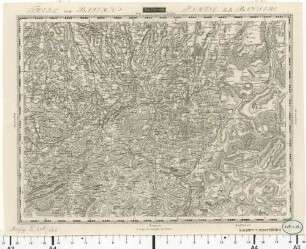
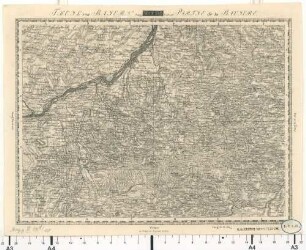
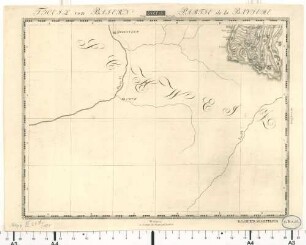
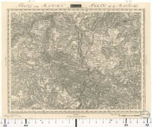
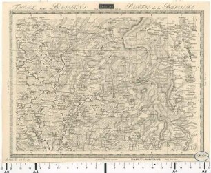
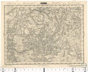
Topographisch-militairische Charte von Teutschland : in 204 Blättern, 155. Theil von Baiern
- Location
-
München, Bayerische Staatsbibliothek -- Mapp. XI,51 d-155
- Extent
-
1 Kt.
- Bibliographic citation
-
Topographisch-militairische Charte von Teutschland ; 155
- Event
-
Veröffentlichung
- (where)
-
Weimar
- (who)
-
Verlag des Geograph. Instituts
- (when)
-
[ca. 1810]
- Event
-
Veröffentlichung
- (where)
-
Weimar
- (who)
-
im Verlage des Geograph. Instituts
- (when)
-
[ca. 1810]
- Contributor
- URN
-
urn:nbn:de:bvb:12-bsb00010967-2
- Last update
-
16.04.2025, 8:33 AM CEST
Data provider
This object is provided by:
Bayerische Staatsbibliothek. If you have any questions about the object, please contact the data provider.
Bayerische Staatsbibliothek. If you have any questions about the object, please contact the data provider.
Associated
- Geographisches Institut zu Weimar
- Verlag des Geograph. Instituts
- im Verlage des Geograph. Instituts
Time of origin
- [ca. 1810]
Other Objects (12)
Topographisch-militairische Charte von Teutschland : in 204 Blättern, 166. Theil von Baiern
Topographisch-militairische Charte von Teutschland : in 204 Blättern, 158. Theil von Baiern
Topographisch-militairische Charte von Teutschland : in 204 Blättern, 181. Theil von Baiern
Topographisch-militairische Charte von Teutschland : in 204 Blättern, 147. Theil von Baiern
Topographisch-militairische Charte von Teutschland : in 204 Blättern, 122. Theil von Baiern
Topographisch-militairische Charte von Teutschland : in 204 Blättern, 146. Theil von Baiern
Topographisch-militairische Charte von Teutschland : in 204 Blättern, 173. Theil von Baiern
Topographisch-militairische Charte von Teutschland : in 204 Blättern, 145. Theil von Baiern
Topographisch-militairische Charte von Teutschland : in 204 Blättern, 121. Theil von Baiern
![Theil von Baiern (Neustadt) [Topographisch-militairische Charte von Teutschland]](https://iiif.deutsche-digitale-bibliothek.de/image/2/33488d73-1e6e-427c-b1c7-8dca86c0c5d5/full/!306,450/0/default.jpg)
Theil von Baiern (Neustadt) [Topographisch-militairische Charte von Teutschland]
![Theil von Baiern (Feldkirch) [Topographisch-militairische Charte von Teutschland]](https://iiif.deutsche-digitale-bibliothek.de/image/2/10b90e93-1449-437e-b87c-cae46ff47e2b/full/!306,450/0/default.jpg)
Theil von Baiern (Feldkirch) [Topographisch-militairische Charte von Teutschland]
![Theil von Baiern (Chur) [Topographisch-militairische Charte von Teutschland]](https://iiif.deutsche-digitale-bibliothek.de/image/2/06ab1c7c-6c40-4c5e-88de-c39bbe44de48/full/!306,450/0/default.jpg)
Theil von Baiern (Chur) [Topographisch-militairische Charte von Teutschland]
Topographisch-militairische Charte von Teutschland : in 204 Blättern, 166. Theil von Baiern
Topographisch-militairische Charte von Teutschland : in 204 Blättern, 158. Theil von Baiern
Topographisch-militairische Charte von Teutschland : in 204 Blättern, 181. Theil von Baiern
Topographisch-militairische Charte von Teutschland : in 204 Blättern, 147. Theil von Baiern
Topographisch-militairische Charte von Teutschland : in 204 Blättern, 122. Theil von Baiern
Topographisch-militairische Charte von Teutschland : in 204 Blättern, 146. Theil von Baiern
Topographisch-militairische Charte von Teutschland : in 204 Blättern, 173. Theil von Baiern
Topographisch-militairische Charte von Teutschland : in 204 Blättern, 145. Theil von Baiern
Topographisch-militairische Charte von Teutschland : in 204 Blättern, 121. Theil von Baiern
Theil von Baiern (Neustadt) [Topographisch-militairische Charte von Teutschland]
Theil von Baiern (Feldkirch) [Topographisch-militairische Charte von Teutschland]