Karten / Pläne
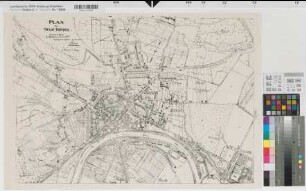
Höxter (Höxter) Stadtplan und Umgebung (Vorder- und Rückseite) von 1939 1 : 5000/50 000 33 x 34 Druck
- Reference number
-
W 051, 12912
- Further information
-
Ort: Höxter, Höxter
- Context
-
Karten A (Allgemein) >> 1. Topographische Karte, Übersichtskarten >> 1.5. Stadt-/ Ortspläne
- Holding
-
W 051 Karten A (Allgemein)
- Indexentry place
-
Höxter, Höxter
Höxter, Stadtplan, 1939
- Provenance
-
Sammlungsregistraturbildner
- Date of creation
-
1939
- Other object pages
- Delivered via
- Last update
-
07.03.2025, 10:22 AM CET
Data provider
This object is provided by:
Landesarchiv Nordrhein-Westfalen. Abteilung Westfalen. If you have any questions about the object, please contact the data provider.
Landesarchiv Nordrhein-Westfalen. Abteilung Westfalen. If you have any questions about the object, please contact the data provider.
Object type
- Karten / Pläne
Associated
- Sammlungsregistraturbildner
Time of origin
- 1939
Other Objects (12)
Höxter (Höxter) Stadtplan 1938 1 : 5000 48 x 68,5 Pause Stadtbauamt

Stadtplan Höxter 5. Auflage
Stadtplan / Umgebungskarte von Höxter/Corvey
Karte der Umgebung von Höxter und Rückseitig ein Stadtplan von Höxter
Höxter, Bahnhof Höxter
Höxter, Krs. Höxter Hudebefreiung
Höxter, Krs. Höxter Hudebefreiung
Höxter, Krs. Höxter Separation
Stadtwerke Höxter in Höxter;
Höxter, Krs. Höxter Hudebefreiung
Höxter, Krs. Höxter Hudebefreiung
Höxter, Einsenbahn-Betriebsamt Höxter
Höxter (Höxter) Stadtplan 1938 1 : 5000 48 x 68,5 Pause Stadtbauamt
Stadtplan Höxter 5. Auflage
Stadtplan / Umgebungskarte von Höxter/Corvey
Karte der Umgebung von Höxter und Rückseitig ein Stadtplan von Höxter
Höxter, Bahnhof Höxter
Höxter, Krs. Höxter Hudebefreiung
Höxter, Krs. Höxter Hudebefreiung
Höxter, Krs. Höxter Separation
Stadtwerke Höxter in Höxter;
Höxter, Krs. Höxter Hudebefreiung
Höxter, Krs. Höxter Hudebefreiung