Luftbildpläne
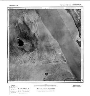
Harvestehude, Gauß-Krüger-Koordinaten: Rechtswert: 3564, Hochwert: 5938
- Reference number
-
RW 0230, 399
- Dimensions
-
Höhe: 60, Breite: 60, Maßstab: 1:5.000
- Context
-
Hansa Luftbild AG, Luftbildpläne 1951-1970 >> 6. Rechswerte beginnend mit 35 >> 6.34. 3564
- Holding
-
RW 0230 Hansa Luftbild AG, Luftbildpläne 1951-1970
- Provenance
-
Hansa Luftbild
- Date of creation
-
5.6.1952
- Other object pages
- Delivered via
- Zugangsbeschränkungen
-
Digitalisat vorhanden: Original für die Nutzung gesperrt. Digitalisat vorhanden
- Last update
-
07.03.2025, 9:52 AM CET
Data provider
This object is provided by:
Landesarchiv Nordrhein-Westfalen. Abteilung Rheinland. If you have any questions about the object, please contact the data provider.
Landesarchiv Nordrhein-Westfalen. Abteilung Rheinland. If you have any questions about the object, please contact the data provider.
Object type
- Luftbildpläne
Associated
- Hansa Luftbild
Time of origin
- 5.6.1952
Other Objects (12)

Harvestehude, Gauß-Krüger-Koordinaten: Rechtswert: 3564, Hochwert: 5938
Speckbüttel, Gauß-Krüger-Koordinaten: Rechtswert: 3472, Hochwert: 5938
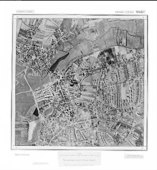
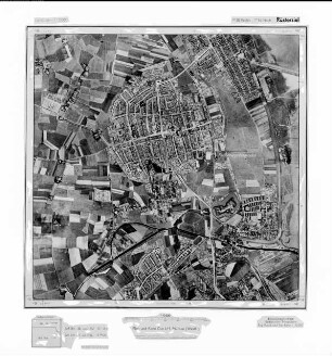
Wedel, Gauß-Krüger-Koordinaten: Rechtswert: 3546, Hochwert: 5938
Tromschlag, Gauß-Krüger-Koordinaten: Rechtswert: 2572, Hochwert: 5938
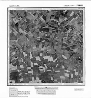
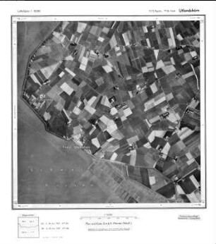
Burhave, Gauß-Krüger-Koordinaten: Rechtswert: 3456, Hochwert: 5938
Iserbrook, Gauß-Krüger-Koordinaten: Rechtswert: 3554, Hochwert: 5938
Wedel, Gauß-Krüger-Koordinaten: Rechtswert: 3546, Hochwert: 5938
Fedderwardergroden, Gauß-Krüger-Koordinaten: Rechtswert: 3438, Hochwert: 5938
Laven, Gauß-Krüger-Koordinaten: Rechtswert: 3478, Hochwert: 5938
![[Wasserfläche], Gauß-Krüger-Koordinaten: Rechtswert: 3444, Hochwert: 5938](https://iiif.deutsche-digitale-bibliothek.de/image/2/c42ac575-12f8-41f0-9c16-19b7d73a050c/full/!306,450/0/default.jpg)
[Wasserfläche], Gauß-Krüger-Koordinaten: Rechtswert: 3444, Hochwert: 5938
Stromkaje, Gauß-Krüger-Koordinaten: Rechtswert: 3468, Hochwert: 5938
Wandsbek, Gauß-Krüger-Koordinaten: Rechtswert: 3570, Hochwert: 5938
Harvestehude, Gauß-Krüger-Koordinaten: Rechtswert: 3564, Hochwert: 5938
Speckbüttel, Gauß-Krüger-Koordinaten: Rechtswert: 3472, Hochwert: 5938
Wedel, Gauß-Krüger-Koordinaten: Rechtswert: 3546, Hochwert: 5938
Tromschlag, Gauß-Krüger-Koordinaten: Rechtswert: 2572, Hochwert: 5938
Burhave, Gauß-Krüger-Koordinaten: Rechtswert: 3456, Hochwert: 5938
Iserbrook, Gauß-Krüger-Koordinaten: Rechtswert: 3554, Hochwert: 5938
Wedel, Gauß-Krüger-Koordinaten: Rechtswert: 3546, Hochwert: 5938
Fedderwardergroden, Gauß-Krüger-Koordinaten: Rechtswert: 3438, Hochwert: 5938
Laven, Gauß-Krüger-Koordinaten: Rechtswert: 3478, Hochwert: 5938
[Wasserfläche], Gauß-Krüger-Koordinaten: Rechtswert: 3444, Hochwert: 5938
Stromkaje, Gauß-Krüger-Koordinaten: Rechtswert: 3468, Hochwert: 5938