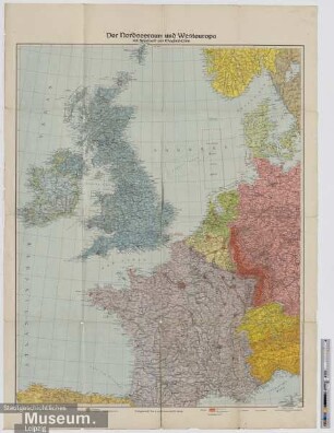
Militärstrategische Karte
Militär-strategische Karte von westlichen Kriegsschauplatz mit Westwall und Maginot-Linie
- Alternative title
-
Westlicher Kriegsschauplatz zu Land und zur See
- Location
-
Deutsches Historisches Museum, Berlin
- Inventory number
-
Do2 2007/789
- Measurements
-
Höhe x Breite: 84,4 x 59,8 cm (aufgeschlagen)
- Material/Technique
-
Karton, Papier, gedruckt
- Classification
-
Kartografie (Gattung)
- Subject (what)
-
Weltkrieg, 2.
Westfront
- Event
-
Herstellung
- (who)
-
Verlag: Dr. Trenkler-Verlag GmbH
- (where)
-
Leipzig, Deutschland [historisch: Deutsches Reich]
- (when)
-
um 1940
- Rights
-
Deutsches Historisches Museum
- Last update
-
24.03.2023, 9:27 AM CET
Data provider
This object is provided by:
Stiftung Deutsches Historisches Museum. If you have any questions about the object, please contact the data provider.
Stiftung Deutsches Historisches Museum. If you have any questions about the object, please contact the data provider.
Object type
- Militärstrategische Karte
Associated
- Verlag: Dr. Trenkler-Verlag GmbH
Time of origin
- um 1940
Other Objects (12)

Westwall und Maginot-Linie

Kriegskarte von Westeuropa mit Westwall und Maginot-Linie
Westwall, Maginot-Linie, Atlantikwall : Bunker- u. Festungsbau 1930 - 1945
Westwall, Maginot-Linie, Atlantikwall : Bunker- u. Festungsbau 1930 - 1945
Der Nordseeraum und Westeuropa mit Westwall und Maginot-Linie
Kriegs-Karte von Westeuropa mit Westwall und Maginot-Linie
Die Maginot-Linie
Karte Westfeldzug (Maginot-Linie)
Hinter der Maginot-Linie
Bildbenutzung Peter Mühlschlegel. - Maginot-Linie
Maginot-Linie an Frankreichs Westgrenze
Zerstörungsfeuer gegen die Maginot-Linie
Westwall und Maginot-Linie
Kriegskarte von Westeuropa mit Westwall und Maginot-Linie
Westwall, Maginot-Linie, Atlantikwall : Bunker- u. Festungsbau 1930 - 1945
Westwall, Maginot-Linie, Atlantikwall : Bunker- u. Festungsbau 1930 - 1945
Der Nordseeraum und Westeuropa mit Westwall und Maginot-Linie
Kriegs-Karte von Westeuropa mit Westwall und Maginot-Linie
Die Maginot-Linie
Karte Westfeldzug (Maginot-Linie)
Hinter der Maginot-Linie
Bildbenutzung Peter Mühlschlegel. - Maginot-Linie
Maginot-Linie an Frankreichs Westgrenze