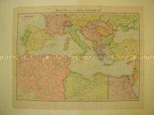
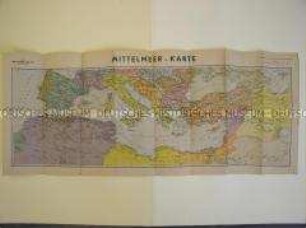
Politisch-administrative Karte
Politisch-administrative Karte des Mittelmeerraumes
- Location
-
Deutsches Historisches Museum, Berlin
- Inventory number
-
Do2 94/3487
- Measurements
-
Höhe x Breite: 41,2 x 52,4 cm
- Material/Technique
-
Papier, gedruckt
- Classification
-
Kartografie (Gattung)
- Subject (what)
-
Geographie
- Event
-
Herstellung
- (who)
-
Herausgeber: Kurt Vowinkel Verlag
- (where)
-
Heidelberg, Deutschland [historisch: Deutsches Reich]
- (when)
-
um 1940
- Rights
-
Deutsches Historisches Museum
- Last update
-
24.03.2023, 9:31 AM CET
Data provider
This object is provided by:
Stiftung Deutsches Historisches Museum. If you have any questions about the object, please contact the data provider.
Stiftung Deutsches Historisches Museum. If you have any questions about the object, please contact the data provider.
Object type
- Politisch-administrative Karte
Associated
- Herausgeber: Kurt Vowinkel Verlag
Time of origin
- um 1940
Other Objects (12)

Politisch-administrative Karte des Mittelmeerraumes
Politisch-administrative Karte des Mittelmeerraumes in französischer Sprache
Politisch-administrative Karte des Mittelmeerraumes und des Nahen Ostens

Politisch-geografische Karte des Mittelmeerraumes
Karte des Mittelmeerraumes
Karte des Mittelmeerraumes
Karte des Mittelmeerraumes
Geografische Karte des Mittelmeerraumes
Pflanzen des Mittelmeerraumes
Politisch-Administrative Karte Osteuropas
Politisch-administrative Karte des Ruhrgebietes
Politisch-administrative Karte des Mittelmeerraums
Politisch-administrative Karte des Mittelmeerraumes
Politisch-administrative Karte des Mittelmeerraumes in französischer Sprache
Politisch-administrative Karte des Mittelmeerraumes und des Nahen Ostens
Politisch-geografische Karte des Mittelmeerraumes
Karte des Mittelmeerraumes
Karte des Mittelmeerraumes
Karte des Mittelmeerraumes
Geografische Karte des Mittelmeerraumes
Pflanzen des Mittelmeerraumes
Politisch-Administrative Karte Osteuropas
Politisch-administrative Karte des Ruhrgebietes