Karten / Pläne
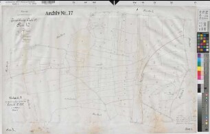
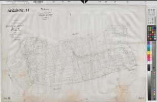
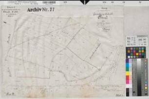
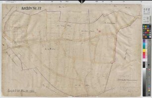
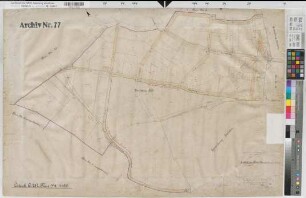
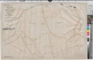
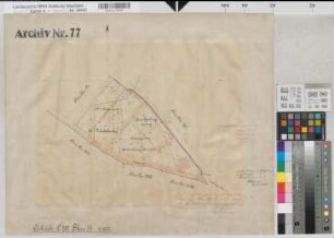
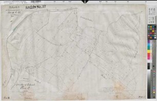
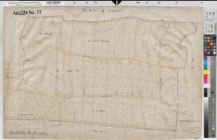
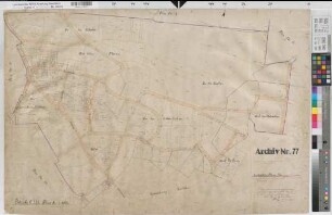
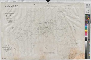
Östrich (Iserlohn), Zusammenlegung Östrich, Urkarte I Iserlohn Flur 8
- Reference number
-
W 051, 39435
- Dimensions
-
Höhe: 50, Breite: 33, Maßstab: 1:1000
- Context
-
Karten A (Allgemein) >> 11. Landesamt für Agrarordnung >> 11.2153. Östrich (Iserlohn), Zusammenlegung Östrich
- Holding
-
W 051 Karten A (Allgemein)
- Date of creation
-
1919
- Other object pages
- Delivered via
- Last update
-
07.03.2025, 10:03 AM CET
Data provider
This object is provided by:
Landesarchiv Nordrhein-Westfalen. Abteilung Westfalen. If you have any questions about the object, please contact the data provider.
Landesarchiv Nordrhein-Westfalen. Abteilung Westfalen. If you have any questions about the object, please contact the data provider.
Object type
- Karten / Pläne
Time of origin
- 1919
Other Objects (12)
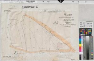
Östrich (Iserlohn), Zusammenlegung Östrich, Urkarte I Iserlohn Flur 30;31
Östrich (Iserlohn), Zusammenlegung Östrich, Urkarte I Flur 10
Östrich (Iserlohn), Zusammenlegung Östrich, Urkarte I Flur 7
Östrich (Iserlohn), Zusammenlegung Östrich, Urkarte I Flur 9
Östrich (Iserlohn), Zusammenlegung Östrich, Urkarte II Flur 33
Östrich (Iserlohn), Zusammenlegung Östrich, Urkarte II Flur 34
Östrich (Iserlohn), Zusammenlegung Östrich, Urkarte II Flur 6
Östrich (Iserlohn), Zusammenlegung Östrich, Urkarte II Flur 35
Östrich (Iserlohn), Zusammenlegung Östrich, Urkarte I Flur 6
Östrich (Iserlohn), Zusammenlegung Östrich, Urkarte II Flur 7
Östrich (Iserlohn), Zusammenlegung Östrich, Urkarte II Flur 8
Östrich (Iserlohn), Zusammenlegung Östrich, Urkarte I Flur 8
Östrich (Iserlohn), Zusammenlegung Östrich, Urkarte I Iserlohn Flur 30;31
Östrich (Iserlohn), Zusammenlegung Östrich, Urkarte I Flur 10
Östrich (Iserlohn), Zusammenlegung Östrich, Urkarte I Flur 7
Östrich (Iserlohn), Zusammenlegung Östrich, Urkarte I Flur 9
Östrich (Iserlohn), Zusammenlegung Östrich, Urkarte II Flur 33
Östrich (Iserlohn), Zusammenlegung Östrich, Urkarte II Flur 34
Östrich (Iserlohn), Zusammenlegung Östrich, Urkarte II Flur 6
Östrich (Iserlohn), Zusammenlegung Östrich, Urkarte II Flur 35
Östrich (Iserlohn), Zusammenlegung Östrich, Urkarte I Flur 6
Östrich (Iserlohn), Zusammenlegung Östrich, Urkarte II Flur 7
Östrich (Iserlohn), Zusammenlegung Östrich, Urkarte II Flur 8