Karten / Pläne
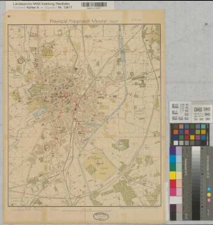
Münster (Münster) Stadtplan 1939 1 : 15 000 73 x 73 farb. Druck: G. A. Hülswitt, Münster Hauptvermessungsabteilung B Nr. 1268c
- Reference number
-
W 051, 15222
- Former reference number
-
B 1268c
- Further information
-
Ort: Münster, Münster
- Context
-
Karten A (Allgemein) >> 1. Topographische Karte, Übersichtskarten >> 1.5. Stadt-/ Ortspläne
- Holding
-
W 051 Karten A (Allgemein)
- Indexentry place
-
Münster, Münster
Münster, Stadtplan, 1939
- Provenance
-
Sammlungsregistraturbildner
- Date of creation
-
1939
- Other object pages
- Delivered via
- Last update
-
07.03.2025, 10:14 AM CET
Data provider
This object is provided by:
Landesarchiv Nordrhein-Westfalen. Abteilung Westfalen. If you have any questions about the object, please contact the data provider.
Landesarchiv Nordrhein-Westfalen. Abteilung Westfalen. If you have any questions about the object, please contact the data provider.
Object type
- Karten / Pläne
Associated
- Sammlungsregistraturbildner
Time of origin
- 1939
Other Objects (12)

Münster (Münster) Stadtplan 1953 1 : 15 000 73 x 73 farb. Druck: Willy Größchen, Dortmund Stadtvermessungsamt B Nr. 1268f

Münster (Münster) Stadtplan 1955 1 : 15 000 73 x 73 farb. Druck: Willy Größchen, Dortmund Stadtvermessungsamt B Nr. 1268h
Münster (Münster) Stadtplan 1931 1 : 15 000 49,5 x 41 farb. Druck: G. A. Hülswitt, Münster Stadtvermessungsamt Bem.: mit Fliegerschaubild der Innenstadt B Nr. 1268d

Münster (Münster) Stadtplan mit Bebauungsgebiet Kinderhaus 1965 1 : 15 000 73 x 72 farb. Druck: W. Größchen, Dortmund Regierung Münster Nr. 34003
Münster (Münster) Stadtplan mit eingezeichneten Bauplätzen nach 1948 73 x 72 Pause Regierung Münster Nr. 33852

Münster (Münster) Stadtplan 1958 1 : 15 000 73 x 73 Druck: Willy Größchen, Dortmund Stadtvermessungsamt B Nr. 1268g
Münster (Münster) Stadtplan mit Einzeichnunng eines Bauplatzes für das Gymnasium Paulinum 1936 1 : 15 000 50 x 41,5 farb. Druck: Hülswitt, Münster, mit Einzeichnungen Prov. Schulkollegium Nr. 4879

Münster (Münster) Stadtplan Rückseite: Innenstadtkarte mit Buslinien und Ansichtsfotos 1962 1 : 15 000 73 x 73 farb. Druck: Willy Größchen, Dortmund Vermessungs- und Katasteramt B Nr. 1268i

Münster (Münster) Stadtplan Rückseite: Innstadtplan mit Buslinien und Fotos 1965 1 : 15 000 73 x 73 farb. Druck: Willy Größchen, Dortmund Vermessungs- und Katasteramt B Nr. 1268k
Münster, Stadt: Grundwassergleichenplan (Anlage 7.3)

Stadtplan Münster
[Stadtplan Münster]
Münster (Münster) Stadtplan 1953 1 : 15 000 73 x 73 farb. Druck: Willy Größchen, Dortmund Stadtvermessungsamt B Nr. 1268f
Münster (Münster) Stadtplan 1955 1 : 15 000 73 x 73 farb. Druck: Willy Größchen, Dortmund Stadtvermessungsamt B Nr. 1268h
Münster (Münster) Stadtplan 1931 1 : 15 000 49,5 x 41 farb. Druck: G. A. Hülswitt, Münster Stadtvermessungsamt Bem.: mit Fliegerschaubild der Innenstadt B Nr. 1268d
Münster (Münster) Stadtplan mit Bebauungsgebiet Kinderhaus 1965 1 : 15 000 73 x 72 farb. Druck: W. Größchen, Dortmund Regierung Münster Nr. 34003
Münster (Münster) Stadtplan mit eingezeichneten Bauplätzen nach 1948 73 x 72 Pause Regierung Münster Nr. 33852
Münster (Münster) Stadtplan 1958 1 : 15 000 73 x 73 Druck: Willy Größchen, Dortmund Stadtvermessungsamt B Nr. 1268g
Münster (Münster) Stadtplan mit Einzeichnunng eines Bauplatzes für das Gymnasium Paulinum 1936 1 : 15 000 50 x 41,5 farb. Druck: Hülswitt, Münster, mit Einzeichnungen Prov. Schulkollegium Nr. 4879
Münster (Münster) Stadtplan Rückseite: Innenstadtkarte mit Buslinien und Ansichtsfotos 1962 1 : 15 000 73 x 73 farb. Druck: Willy Größchen, Dortmund Vermessungs- und Katasteramt B Nr. 1268i
Münster (Münster) Stadtplan Rückseite: Innstadtplan mit Buslinien und Fotos 1965 1 : 15 000 73 x 73 farb. Druck: Willy Größchen, Dortmund Vermessungs- und Katasteramt B Nr. 1268k
Münster, Stadt: Grundwassergleichenplan (Anlage 7.3)
Stadtplan Münster