Luftbildpläne
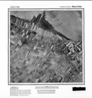
[Wasserfläche], Gauß-Krüger-Koordinaten: Rechtswert: 3446, Hochwert: 5932
- Reference number
-
RW 0230, 2182
- Dimensions
-
Höhe: 60, Breite: 60, Maßstab: 1:10.000
- Context
-
Hansa Luftbild AG, Luftbildpläne 1951-1970 >> 5. Rechswerte beginnend mit 34 >> 5.26. 3446
- Holding
-
RW 0230 Hansa Luftbild AG, Luftbildpläne 1951-1970
- Provenance
-
Hansa Luftbild
- Date of creation
-
28.6.1952
- Other object pages
- Delivered via
- Zugangsbeschränkungen
-
Digitalisat vorhanden: Original für die Nutzung gesperrt. Digitalisat vorhanden
- Last update
-
07.03.2025, 10:49 AM CET
Data provider
This object is provided by:
Landesarchiv Nordrhein-Westfalen. Abteilung Rheinland. If you have any questions about the object, please contact the data provider.
Landesarchiv Nordrhein-Westfalen. Abteilung Rheinland. If you have any questions about the object, please contact the data provider.
Object type
- Luftbildpläne
Associated
- Hansa Luftbild
Time of origin
- 28.6.1952
Other Objects (12)
![[Eckwarderhörne], Gauß-Krüger-Koordinaten: Rechtswert: 3446, Hochwert: 5932](https://iiif.deutsche-digitale-bibliothek.de/image/2/58ca9c53-84c2-4821-9dc5-40a2e41bb3c6/full/!306,450/0/default.jpg)
[Eckwarderhörne], Gauß-Krüger-Koordinaten: Rechtswert: 3446, Hochwert: 5932
![[Wasserfläche], Gauß-Krüger-Koordinaten: Rechtswert: 3446, Hochwert: 5936](https://iiif.deutsche-digitale-bibliothek.de/image/2/6fea8851-8f88-480c-8e22-106b351dc506/full/!306,450/0/default.jpg)
[Wasserfläche], Gauß-Krüger-Koordinaten: Rechtswert: 3446, Hochwert: 5936
![[Wasserfläche], Gauß-Krüger-Koordinaten: Rechtswert: 3446, Hochwert: 5934](https://iiif.deutsche-digitale-bibliothek.de/image/2/18748331-f867-4fd0-9519-31a5c8c1869f/full/!306,450/0/default.jpg)
[Wasserfläche], Gauß-Krüger-Koordinaten: Rechtswert: 3446, Hochwert: 5934
![[Wasserfläche], Gauß-Krüger-Koordinaten: Rechtswert: 3446, Hochwert: 5938](https://iiif.deutsche-digitale-bibliothek.de/image/2/f09ee459-82fd-48bf-9d3a-c1fe1c509a92/full/!306,450/0/default.jpg)
[Wasserfläche], Gauß-Krüger-Koordinaten: Rechtswert: 3446, Hochwert: 5938
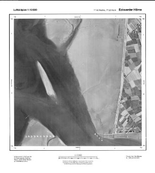
Eckwarder Hörne, Gauß-Krüger-Koordinaten: Rechtswert: 3446, Hochwert: 5932
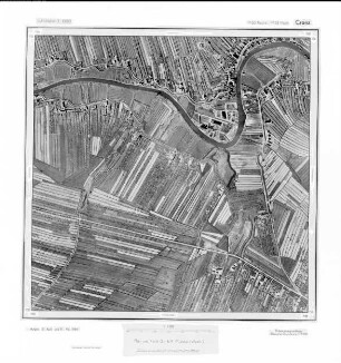
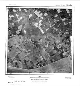
Cranz, Gauß-Krüger-Koordinaten: Rechtswert: 3550, Hochwert: 5932
Cranz, Gauß-Krüger-Koordinaten: Rechtswert: 3550, Hochwert: 5932
![[Eckwarden], Gauß-Krüger-Koordinaten: Rechtswert: 3450, Hochwert: 5932](https://iiif.deutsche-digitale-bibliothek.de/image/2/fdac22a2-0d2d-4c97-b774-6bab5923db5d/full/!306,450/0/default.jpg)
[Eckwarden], Gauß-Krüger-Koordinaten: Rechtswert: 3450, Hochwert: 5932
Fischereihafen, Gauß-Krüger-Koordinaten: Rechtswert: 3470, Hochwert: 5932
Grebswarden, Gauß-Krüger-Koordinaten: Rechtswert: 3466, Hochwert: 5932
Eckwarden, Gauß-Krüger-Koordinaten: Rechtswert: 3450, Hochwert: 5932

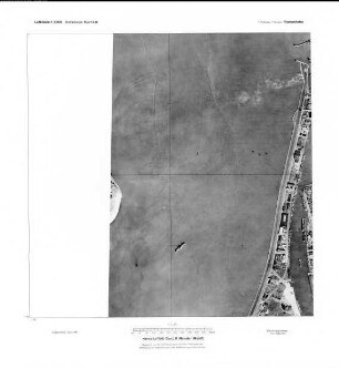
Veddel, Gauß-Krüger-Koordinaten: Rechtswert: 3566, Hochwert: 5932
[Eckwarderhörne], Gauß-Krüger-Koordinaten: Rechtswert: 3446, Hochwert: 5932
[Wasserfläche], Gauß-Krüger-Koordinaten: Rechtswert: 3446, Hochwert: 5936
[Wasserfläche], Gauß-Krüger-Koordinaten: Rechtswert: 3446, Hochwert: 5934
[Wasserfläche], Gauß-Krüger-Koordinaten: Rechtswert: 3446, Hochwert: 5938
Eckwarder Hörne, Gauß-Krüger-Koordinaten: Rechtswert: 3446, Hochwert: 5932
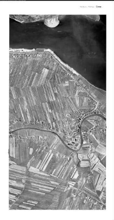
Cranz, Gauß-Krüger-Koordinaten: Rechtswert: 3550, Hochwert: 5932
Cranz, Gauß-Krüger-Koordinaten: Rechtswert: 3550, Hochwert: 5932
[Eckwarden], Gauß-Krüger-Koordinaten: Rechtswert: 3450, Hochwert: 5932
Fischereihafen, Gauß-Krüger-Koordinaten: Rechtswert: 3470, Hochwert: 5932
Grebswarden, Gauß-Krüger-Koordinaten: Rechtswert: 3466, Hochwert: 5932
Eckwarden, Gauß-Krüger-Koordinaten: Rechtswert: 3450, Hochwert: 5932
Veddel, Gauß-Krüger-Koordinaten: Rechtswert: 3566, Hochwert: 5932
[Eckwarderhörne], Gauß-Krüger-Koordinaten: Rechtswert: 3446, Hochwert: 5932
[Wasserfläche], Gauß-Krüger-Koordinaten: Rechtswert: 3446, Hochwert: 5936
[Wasserfläche], Gauß-Krüger-Koordinaten: Rechtswert: 3446, Hochwert: 5934
[Wasserfläche], Gauß-Krüger-Koordinaten: Rechtswert: 3446, Hochwert: 5938
Eckwarder Hörne, Gauß-Krüger-Koordinaten: Rechtswert: 3446, Hochwert: 5932
Cranz, Gauß-Krüger-Koordinaten: Rechtswert: 3550, Hochwert: 5932
Cranz, Gauß-Krüger-Koordinaten: Rechtswert: 3550, Hochwert: 5932
[Eckwarden], Gauß-Krüger-Koordinaten: Rechtswert: 3450, Hochwert: 5932
Fischereihafen, Gauß-Krüger-Koordinaten: Rechtswert: 3470, Hochwert: 5932
Grebswarden, Gauß-Krüger-Koordinaten: Rechtswert: 3466, Hochwert: 5932
Eckwarden, Gauß-Krüger-Koordinaten: Rechtswert: 3450, Hochwert: 5932