Luftbildpläne
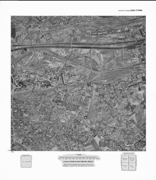
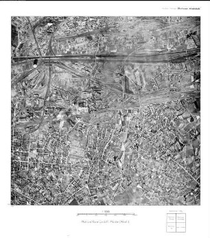
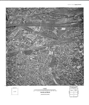
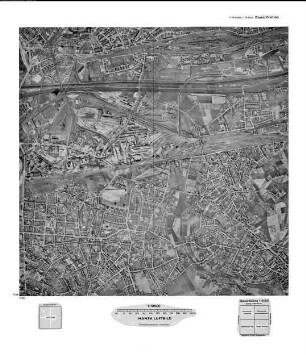
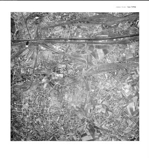
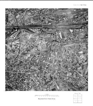
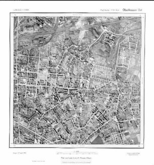
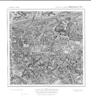
Oberhausen Ost, Gauß-Krüger-Koordinaten: Rechtswert: 2560, Hochwert: 5704
- Reference number
-
RW 0230, 16183
- Dimensions
-
Höhe: 60, Breite: 60, Maßstab: 1:5.000
- Context
-
Hansa Luftbild AG, Luftbildpläne 1951-1970 >> 2. Rechswerte beginnend mit 25 >> 2.39. 2560
- Holding
-
RW 0230 Hansa Luftbild AG, Luftbildpläne 1951-1970
- Provenance
-
Hansa Luftbild
- Date of creation
-
29.4.1966
- Other object pages
- Delivered via
- Zugangsbeschränkungen
-
Digitalisat vorhanden: Original für die Nutzung gesperrt. Digitalisat vorhanden
- Last update
-
07.03.2025, 10:19 AM CET
Data provider
This object is provided by:
Landesarchiv Nordrhein-Westfalen. Abteilung Rheinland. If you have any questions about the object, please contact the data provider.
Landesarchiv Nordrhein-Westfalen. Abteilung Rheinland. If you have any questions about the object, please contact the data provider.
Object type
- Luftbildpläne
Associated
- Hansa Luftbild
Time of origin
- 29.4.1966
Other Objects (12)

Oberhausen Ost, Gauß-Krüger-Koordinaten: Rechtswert: 2560, Hochwert: 5704
Oberhausen Ost, Gauß-Krüger-Koordinaten: Rechtswert: 2560, Hochwert: 5704
Oberhausen Ost, Gauß-Krüger-Koordinaten: Rechtswert: 2560, Hochwert: 5704
Oberhausen Ost, Gauß-Krüger-Koordinaten: Rechtswert: 2560, Hochwert: 5704
Oberhausen Ost, Gauß-Krüger-Koordinaten: Rechtswert: 2560, Hochwert: 5704
Oberhausen Ost, Gauß-Krüger-Koordinaten: Rechtswert: 2560, Hochwert: 5704
Oberhausen Ost, Gauß-Krüger-Koordinaten: Rechtswert: 2560, Hochwert: 5704
Oberhausen Ost, Gauß-Krüger-Koordinaten: Rechtswert: 2560, Hochwert: 5704
Oberhausen Ost, Gauß-Krüger-Koordinaten: Rechtswert: 2560, Hochwert: 5704

Oberhausen Ost, Gauß-Krüger-Koordinaten: Rechtswert: 2560, Hochwert: 5704
Oberhausen Ost, Gauß-Krüger-Koordinaten: Rechtswert: 2560, Hochwert: 5704
Oberhausen Ost, Gauß-Krüger-Koordinaten: Rechtswert: 2560, Hochwert: 5704
Oberhausen Ost, Gauß-Krüger-Koordinaten: Rechtswert: 2560, Hochwert: 5704
Oberhausen Ost, Gauß-Krüger-Koordinaten: Rechtswert: 2560, Hochwert: 5704
Oberhausen Ost, Gauß-Krüger-Koordinaten: Rechtswert: 2560, Hochwert: 5704
Oberhausen Ost, Gauß-Krüger-Koordinaten: Rechtswert: 2560, Hochwert: 5704
Oberhausen Ost, Gauß-Krüger-Koordinaten: Rechtswert: 2560, Hochwert: 5704
Oberhausen Ost, Gauß-Krüger-Koordinaten: Rechtswert: 2560, Hochwert: 5704
Oberhausen Ost, Gauß-Krüger-Koordinaten: Rechtswert: 2560, Hochwert: 5704
Oberhausen Ost, Gauß-Krüger-Koordinaten: Rechtswert: 2560, Hochwert: 5704
Oberhausen Ost, Gauß-Krüger-Koordinaten: Rechtswert: 2560, Hochwert: 5704
Oberhausen Ost, Gauß-Krüger-Koordinaten: Rechtswert: 2560, Hochwert: 5704
Oberhausen Ost, Gauß-Krüger-Koordinaten: Rechtswert: 2560, Hochwert: 5704
Oberhausen Ost, Gauß-Krüger-Koordinaten: Rechtswert: 2560, Hochwert: 5704
Oberhausen Ost, Gauß-Krüger-Koordinaten: Rechtswert: 2560, Hochwert: 5704
Oberhausen Ost, Gauß-Krüger-Koordinaten: Rechtswert: 2560, Hochwert: 5704
Oberhausen Ost, Gauß-Krüger-Koordinaten: Rechtswert: 2560, Hochwert: 5704
Oberhausen Ost, Gauß-Krüger-Koordinaten: Rechtswert: 2560, Hochwert: 5704
Oberhausen Ost, Gauß-Krüger-Koordinaten: Rechtswert: 2560, Hochwert: 5704
Oberhausen Ost, Gauß-Krüger-Koordinaten: Rechtswert: 2560, Hochwert: 5704
Oberhausen Ost, Gauß-Krüger-Koordinaten: Rechtswert: 2560, Hochwert: 5704
Oberhausen Ost, Gauß-Krüger-Koordinaten: Rechtswert: 2560, Hochwert: 5704
Oberhausen Ost, Gauß-Krüger-Koordinaten: Rechtswert: 2560, Hochwert: 5704
Oberhausen Ost, Gauß-Krüger-Koordinaten: Rechtswert: 2560, Hochwert: 5704
Oberhausen Ost, Gauß-Krüger-Koordinaten: Rechtswert: 2560, Hochwert: 5704