Druck
Karte vom Herzogtum Braunschweig-Lüneburg, 1:510 000, Kupferstich, nach 1709 : A New and Exact Map of the Electorate of Brunswick-Lunenburg ant ye rest of ye Kings Dominions in Germany : Very much Improved by ye kind Assistance of severall Curiosus Gentlemen, natives of those Countries ; To His Most Sacred Majesty George King of Great Britain, France and Ireland, Elector of Brunswick-Luneburg &c. / by ... Herman Moll. - [Ca. 1:510 000]. - London : Philip Overton , [nach 1709]. - 1 Kt. : Kupferstich ; 60 x 50 cm. Maßstab in graph. Form (Miles of Great Britain, German Leagues). - Mit Erl. auf d. Kt.-Feld. - Mit 2 Nebenkt.: A Map of Part of England, the United Provinces, Westphalia, and all the Dominions of the King of Great Britain in Germany, Shewing the Rout of the Kings Journey from Hannover to Greenwich &c. The Dutche of Saxon Lauwenburg. - Titelkartusche unten links
A New and Exact Map of the Electorate of Brunswick-Lunenburg ant ye rest of ye Kings Dominions in Germany : Very much Improved by ye kind Assistance of severall Curiosus Gentlemen, natives of those Countries ; To His Most Sacred Majesty George King of Great Britain, France and Ireland, Elector of Brunswick-Luneburg &c. / by ... Herman Moll. - [Ca. 1:510 000]. - London : Philip Overton , [nach 1709]. - 1 Kt. : Kupferstich ; 60 x 50 cm. Maßstab in graph. Form (Miles of Great Britain, German Leagues). - Mit Erl. auf d. Kt.-Feld. - Mit 2 Nebenkt.: A Map of Part of England, the United Provinces, Westphalia, and all the Dominions of the King of Great Britain in Germany, Shewing the Rout of the Kings Journey from Hannover to Greenwich &c. The Dutche of Saxon Lauwenburg. - Titelkartusche unten links
Datensatz in color
- Standort
-
Sächsische Landesbibliothek - Staats- und Universitätsbibliothek Dresden (SLUB), Kartensammlung
- Inventarnummer
-
SLUB/KS A14757
- Weitere Nummer(n)
-
df_dk_0011339 (Aufnahmenummer)
90017163 (Dokumentennummer)
ppn325753008 (Verzeichnis/PPN)
kxpppn1649834691 (Verzeichnis/PPN)
1649834691 (Verzeichnis/PPN)
- Maße
-
60 x 50 cm (Werk/Vorlage)
1:510000 (Maßstab Werk/Vorlage)
- Klassifikation
-
Druckgrafik (Gattung)
- Bezug (was)
-
Grenzen
Wappen
- Bezug (wo)
-
Osnabrück (Dargestellter Ort)
Lüneburg (Dargestellter Ort)
Wolfenbüttel (Dargestellter Ort)
Göttingen (Dargestellter Ort)
Minden (Dargestellter Ort)
- Bezug (Ereignis)
-
Herstellung
- (wer)
-
Moll, Herman (Kartograph)
Overton, Philip (Verleger)
- (wann)
-
nach 1709
- (Beschreibung)
-
Erschaffung abgebildetes Objekt
Kupferstich (Material/Technik)
- Ereignis
-
Fotografische Aufnahme
- (wann)
-
2009
- Förderung
-
Digitalisierungsprojekt: DFG-Karten
- Rechteinformation
-
Bitte beachten Sie die Nutzungsbedingungen der Deutschen Fotothek.
- Letzte Aktualisierung
-
05.03.2025, 16:23 MEZ
Datenpartner
Deutsche Fotothek. Bei Fragen zum Objekt wenden Sie sich bitte an den Datenpartner.
Objekttyp
- Druck
Beteiligte
- Moll, Herman (Kartograph)
- Overton, Philip (Verleger)
Entstanden
- 2009
- nach 1709
Ähnliche Objekte (12)

Ye reste of ye Wearie
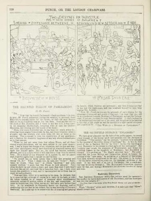
Two desynes for tapystrie for ye new houses of parliament shewing ye dyfferance betweene ye begynnyng of ye session and ye ende
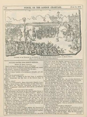
Prospect of ye trooping of ye colour on ye Horse Guards Parade during yer Roman period
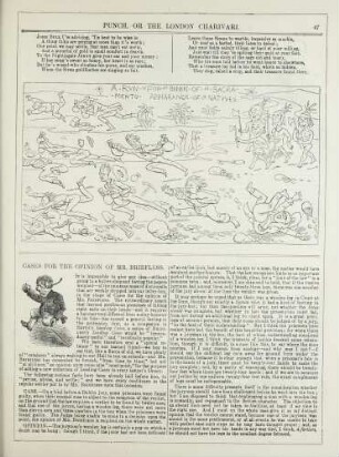
A run upon ye bankes of ye Sacramento appearance of ye natives; Cases for the opinion of Mr. Briefless
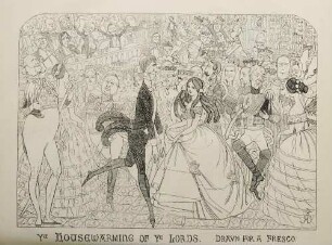
Ye housewarming of ye Lords. Drawn for a fresco

Ye most pleasaunte dreame of Cœlebs ye Cambridge fellowe
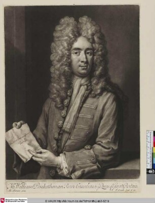
Mr William Penkethman Sworn Comedian to ye Queen of Great Britain
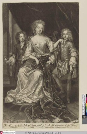
Her Grace the Dutchess of Monmouth ye Earle of Doncaster & ye Lord Henry
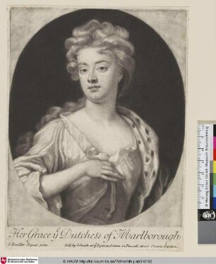
Her Grace ye Dutchess of Marlborough
"JiucYeYE
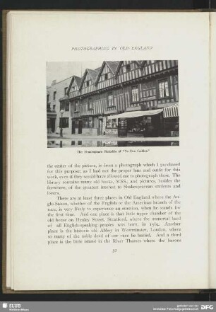
The Shakespeare Hostelrie of "Ye Five Gables"

Examples of "Kake-mono-yè" By Harunobu
Ye reste of ye Wearie
Two desynes for tapystrie for ye new houses of parliament shewing ye dyfferance betweene ye begynnyng of ye session and ye ende
Prospect of ye trooping of ye colour on ye Horse Guards Parade during yer Roman period
A run upon ye bankes of ye Sacramento appearance of ye natives; Cases for the opinion of Mr. Briefless
Ye housewarming of ye Lords. Drawn for a fresco
Ye most pleasaunte dreame of Cœlebs ye Cambridge fellowe
Mr William Penkethman Sworn Comedian to ye Queen of Great Britain
Her Grace the Dutchess of Monmouth ye Earle of Doncaster & ye Lord Henry
Her Grace ye Dutchess of Marlborough
"JiucYeYE
The Shakespeare Hostelrie of "Ye Five Gables"