Karten / Pläne
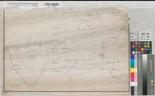
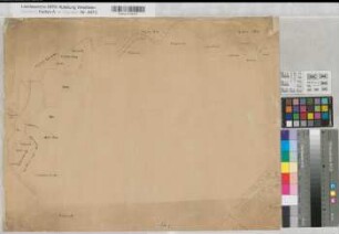
Münsterland topographische Karte Sektion 7 der Specialkarte von Deutschland, Niederlande und Belgien 1.H. 19.Jh. 1 : 200 000 46,5 x 64 Lithographie: Verlag Holle, Wolfenbüttel R. Diederich
- Reference number
-
W 051, 11992
- Further information
-
Ort: Münsterland
- Context
-
Karten A (Allgemein) >> 1. Topographische Karte, Übersichtskarten >> 1.1. Geographische, topographische Karten
- Holding
-
W 051 Karten A (Allgemein)
- Indexentry place
-
Münsterland
Belgien, topographische Karte s. Münsterland, 1825
Deutschland, topographische Karte s. Münsterland, 1825
Münsterland, topographische Karte, 1825
Niederlande, topographische Karte s. Münsterland, 1825
- Provenance
-
Sammlungsregistraturbildner
- Date of creation
-
1825
- Other object pages
- Delivered via
- Last update
-
07.03.2025, 10:01 AM CET
Data provider
This object is provided by:
Landesarchiv Nordrhein-Westfalen. Abteilung Westfalen. If you have any questions about the object, please contact the data provider.
Landesarchiv Nordrhein-Westfalen. Abteilung Westfalen. If you have any questions about the object, please contact the data provider.
Object type
- Karten / Pläne
Associated
- Sammlungsregistraturbildner
Time of origin
- 1825
Other Objects (12)
Allagen (Warstein) Gemeinheitsteilung Teilungsregister 1.H. 19.Jh. Heft KSA Nr. 1620d
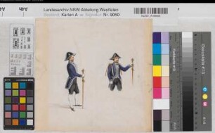
Uniformen 1.H. 19.Jh. 23 x 24 Aquarell Landsberg-Velen Nr. 705a
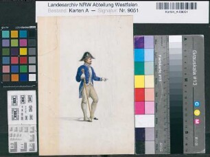
Uniformen 1.H. 19.Jh. 24 x 16,5 Aquarell Landsberg-Velen Nr. 705b
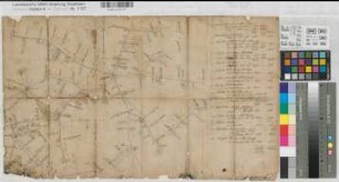
Münster (Reg.Bez.) Entfernungskarte 1.H. 19.Jh. o.M. 35 x 58 Skizze KSM Nr. 614
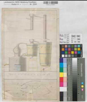
Destillierapparat 1.H. 19.Jh. 12 Fuß = 18 cm 41 x 25 kol. Zeichnung KSM Nr. 842
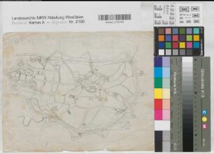
Enniger (Ennigerloh) Einzelgrundstücke 1.H. 19.Jh. o.M. 41 x 62 kol. Zeichnung KSM Nr. 570
Münster (Münster) Stadtplan 1.H. 19.Jh. o.M. 25,5 x 32 Kopie KSM Nr. 753z
Bentlage? (Rheine) Portaltreppe Grundriß, Ansicht 1.H. 19.Jh. o.M. 21 x 24 kol. Zeichnung Bentlage
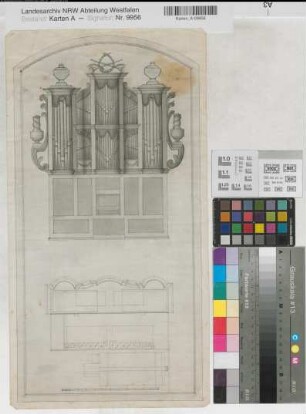
Orgelprospekt und Grundriß 1.H. 19.Jh. o.M. 47.4 x 24,1 Zeichnung Nachlaß Roetzel Nr. 18
Lippe Umflut bei Lippstadt 1.H. 19.Jh. o.M. 44 x 58 Zeichnung KSM IV Nr. 52
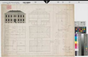
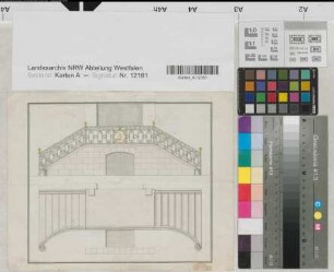
Arnsberg (Arnsberg) Entwurf einer Knabenschule Grundrisse, Ansicht, Schnitte, Details 1.H. 19.Jh. 80 Fuß = 22,3 cm 46,5 x 66 Zeichnung entworfen: Buchholtz gezeichnet: Perizonius KSA Nr. 1414
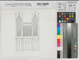
Orgelprospekt und Grundriß 1.H. 19.Jh. o.M. 29,1 x 31,9 Zeichnung Nachlaß Roetzel Nr. 25
Allagen (Warstein) Gemeinheitsteilung Teilungsregister 1.H. 19.Jh. Heft KSA Nr. 1620d
Uniformen 1.H. 19.Jh. 23 x 24 Aquarell Landsberg-Velen Nr. 705a
Uniformen 1.H. 19.Jh. 24 x 16,5 Aquarell Landsberg-Velen Nr. 705b
Münster (Reg.Bez.) Entfernungskarte 1.H. 19.Jh. o.M. 35 x 58 Skizze KSM Nr. 614
Destillierapparat 1.H. 19.Jh. 12 Fuß = 18 cm 41 x 25 kol. Zeichnung KSM Nr. 842
Enniger (Ennigerloh) Einzelgrundstücke 1.H. 19.Jh. o.M. 41 x 62 kol. Zeichnung KSM Nr. 570
Münster (Münster) Stadtplan 1.H. 19.Jh. o.M. 25,5 x 32 Kopie KSM Nr. 753z
Bentlage? (Rheine) Portaltreppe Grundriß, Ansicht 1.H. 19.Jh. o.M. 21 x 24 kol. Zeichnung Bentlage
Orgelprospekt und Grundriß 1.H. 19.Jh. o.M. 47.4 x 24,1 Zeichnung Nachlaß Roetzel Nr. 18
Lippe Umflut bei Lippstadt 1.H. 19.Jh. o.M. 44 x 58 Zeichnung KSM IV Nr. 52
Arnsberg (Arnsberg) Entwurf einer Knabenschule Grundrisse, Ansicht, Schnitte, Details 1.H. 19.Jh. 80 Fuß = 22,3 cm 46,5 x 66 Zeichnung entworfen: Buchholtz gezeichnet: Perizonius KSA Nr. 1414