Luftbildpläne
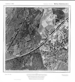
Bottrop, Bischofssondern, Gauß-Krüger-Koordinaten: Rechtswert: 2562, Hochwert: 5712
- Reference number
-
RW 0427, 1361
- Dimensions
-
Höhe: 60, Breite: 60, Maßstab: 1:10.000
- Context
-
Ministerium für Umwelt, Raumordnung und Landwirtschaft: Luftbildpläne >> 10. Nrn. 1239-1367
- Holding
-
RW 0427 Ministerium für Umwelt, Raumordnung und Landwirtschaft: Luftbildpläne
- Provenance
-
Ministerium für Umwelt, Raumordnung und Landwirtschaft
- Date of creation
-
1969
- Other object pages
- Delivered via
- Last update
-
07.03.2025, 10:22 AM CET
Data provider
This object is provided by:
Landesarchiv Nordrhein-Westfalen. Abteilung Rheinland. If you have any questions about the object, please contact the data provider.
Landesarchiv Nordrhein-Westfalen. Abteilung Rheinland. If you have any questions about the object, please contact the data provider.
Object type
- Luftbildpläne
Associated
- Ministerium für Umwelt, Raumordnung und Landwirtschaft
Time of origin
- 1969
Other Objects (12)
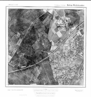
Bottrop - Bischofssondern, Gauß-Krüger-Koordinaten: Rechtswert: 2562, Hochwert: 5712

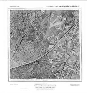
Bottrop, Bischofssondern, Gauß-Krüger-Koordinaten: Rechtswert: 2562, Hochwert: 5712
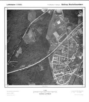
Bottrop, Bischofssondern, Gauß-Krüger-Koordinaten: Rechtswert: 2562, Hochwert: 5712
Bottrop Bischofssondern, Gauß-Krüger-Koordinaten: Rechtswert: 2562, Hochwert: 5712
Bottrop, Bischofssondern, Gauß-Krüger-Koordinaten: Rechtswert: 2562, Hochwert: 5712
Bottrop - Bischofssondern, Gauß-Krüger-Koordinaten: Rechtswert: 2562, Hochwert: 5712
Bottrop, Bischofssondern, Gauß-Krüger-Koordinaten: Rechtswert: 2562, Hochwert: 5712
Bottrop Bischofssondern, Gauß-Krüger-Koordinaten: Rechtswert: 2562, Hochwert: 5712
Bottrop Bischofssondern, Gauß-Krüger-Koordinaten: Rechtswert: 2562, Hochwert: 5712
Bottrop Bischofssondern, Gauß-Krüger-Koordinaten: Rechtswert: 2562, Hochwert: 5712
Bottrop, Bischofssondern, Gauß-Krüger-Koordinaten: Rechtswert: 2562, Hochwert: 5712
Bottrop Bischofssondern, Gauß-Krüger-Koordinaten: Rechtswert: 2562, Hochwert: 5712
Bottrop - Bischofssondern, Gauß-Krüger-Koordinaten: Rechtswert: 2562, Hochwert: 5712
Bottrop, Bischofssondern, Gauß-Krüger-Koordinaten: Rechtswert: 2562, Hochwert: 5712
Bottrop, Bischofssondern, Gauß-Krüger-Koordinaten: Rechtswert: 2562, Hochwert: 5712
Bottrop Bischofssondern, Gauß-Krüger-Koordinaten: Rechtswert: 2562, Hochwert: 5712
Bottrop, Bischofssondern, Gauß-Krüger-Koordinaten: Rechtswert: 2562, Hochwert: 5712
Bottrop - Bischofssondern, Gauß-Krüger-Koordinaten: Rechtswert: 2562, Hochwert: 5712
Bottrop, Bischofssondern, Gauß-Krüger-Koordinaten: Rechtswert: 2562, Hochwert: 5712
Bottrop Bischofssondern, Gauß-Krüger-Koordinaten: Rechtswert: 2562, Hochwert: 5712
Bottrop Bischofssondern, Gauß-Krüger-Koordinaten: Rechtswert: 2562, Hochwert: 5712
Bottrop Bischofssondern, Gauß-Krüger-Koordinaten: Rechtswert: 2562, Hochwert: 5712
Bottrop, Bischofssondern, Gauß-Krüger-Koordinaten: Rechtswert: 2562, Hochwert: 5712
Bottrop Bischofssondern, Gauß-Krüger-Koordinaten: Rechtswert: 2562, Hochwert: 5712
Bottrop - Bischofssondern, Gauß-Krüger-Koordinaten: Rechtswert: 2562, Hochwert: 5712
Bottrop, Bischofssondern, Gauß-Krüger-Koordinaten: Rechtswert: 2562, Hochwert: 5712
Bottrop, Bischofssondern, Gauß-Krüger-Koordinaten: Rechtswert: 2562, Hochwert: 5712
Bottrop Bischofssondern, Gauß-Krüger-Koordinaten: Rechtswert: 2562, Hochwert: 5712
Bottrop, Bischofssondern, Gauß-Krüger-Koordinaten: Rechtswert: 2562, Hochwert: 5712
Bottrop - Bischofssondern, Gauß-Krüger-Koordinaten: Rechtswert: 2562, Hochwert: 5712
Bottrop, Bischofssondern, Gauß-Krüger-Koordinaten: Rechtswert: 2562, Hochwert: 5712
Bottrop Bischofssondern, Gauß-Krüger-Koordinaten: Rechtswert: 2562, Hochwert: 5712
Bottrop Bischofssondern, Gauß-Krüger-Koordinaten: Rechtswert: 2562, Hochwert: 5712
Bottrop Bischofssondern, Gauß-Krüger-Koordinaten: Rechtswert: 2562, Hochwert: 5712
Bottrop, Bischofssondern, Gauß-Krüger-Koordinaten: Rechtswert: 2562, Hochwert: 5712