Karten und Pläne
Topographisch-militärische Karte von Deutschland in 204 Blättern
Enthält auch: Übersichtstabelle des Topographisch-militärischen Atlasses vom Königreiche Preussen in 30 Blättern
- Reference number
-
Landesarchiv Baden-Württemberg, Abt. Staatsarchiv Wertheim, R-K Nr. 7776
- Dimensions
-
49,5 x 61,5 / 49,5 x 32 (Höhe x Breite)
- Further information
-
Ausführung: Druck
- Context
-
Karten und Pläne >> A. Allgemein
- Holding
-
Landesarchiv Baden-Württemberg, Abt. Staatsarchiv Wertheim, R-K Karten und Pläne
- Indexentry place
-
Deutschland
Preußen
- Creator
-
Autor/Fotograf: Geographisches Institut Weimar
- Date of creation
-
31. März 1813
- Other object pages
- Rights
-
Es gelten die Nutzungsbedingungen des Landesarchivs Baden-Württemberg.
- Last update
-
26.03.2024, 9:04 AM CET
Data provider
This object is provided by:
Landesarchiv Baden-Württemberg. If you have any questions about the object, please contact the data provider.
Landesarchiv Baden-Württemberg. If you have any questions about the object, please contact the data provider.
Object type
- Karten und Pläne
Associated
- Autor/Fotograf: Geographisches Institut Weimar
Time of origin
- 31. März 1813
Other Objects (12)
!["Topographisch-militärische Karten von Teutschland in 204 Blatt [...]"](/assets/placeholder/searchResultMediaNoDigitisedMedia.png)
"Topographisch-militärische Karten von Teutschland in 204 Blatt [...]"
"Topographisch-militärische Karten von Teutschland in 204 Blatt [...]"
"Topographisch-militärische Karten von Teutschland in 204 Blatt [...]"
"Topographisch-militärische Karten von Teutschland in 204 Blatt [...]"
"Topographisch-militärische Karten von Teutschland in 204 Blatt [...]"
"Topographisch-militärische Karten von Teutschland in 204 Blatt [...]"
"Topographisch-militärische Karten von Teutschland in 204 Blatt [...]"
"Topographisch-militärische Karten von Teutschland in 204 Bl. [...]"
Korrespondenz mit dem geographischen Institut zu Weimar über die topographisch- militärische Karte von Deutschland in 204 Blättern sowie andere Karten
"Theil von Schlesien". Sect. 75 der Topographisch-militärischen Karte von Teutschland in 204 Sectionen
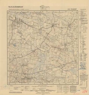
1320 (alte Nr.: 204) Drelsdorf, Topographische Karte 1:25000 (4-cm - Karte)
Topographische Karte von Deutschland
"Topographisch-militärische Karten von Teutschland in 204 Blatt [...]"
"Topographisch-militärische Karten von Teutschland in 204 Blatt [...]"
"Topographisch-militärische Karten von Teutschland in 204 Blatt [...]"
"Topographisch-militärische Karten von Teutschland in 204 Blatt [...]"
"Topographisch-militärische Karten von Teutschland in 204 Blatt [...]"
"Topographisch-militärische Karten von Teutschland in 204 Blatt [...]"
"Topographisch-militärische Karten von Teutschland in 204 Blatt [...]"
"Topographisch-militärische Karten von Teutschland in 204 Bl. [...]"
Korrespondenz mit dem geographischen Institut zu Weimar über die topographisch- militärische Karte von Deutschland in 204 Blättern sowie andere Karten
"Theil von Schlesien". Sect. 75 der Topographisch-militärischen Karte von Teutschland in 204 Sectionen
1320 (alte Nr.: 204) Drelsdorf, Topographische Karte 1:25000 (4-cm - Karte)