- Reference number
-
P 1, 1304
- Former reference number
-
Sonstige Behördensignaturen: P 1, G 15 Erbach M 2019
- Dimensions
-
27,5 x 26 cm
- Further information
-
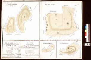
Weitere Angaben (Karte/Plan): Maßstab: 1:10.000
Weitere Angaben (Karte/Plan): Ausführung: Kaliko, koloriert
Weitere Angaben (Karte/Plan): Blattzahl: 1
Vermerke: Deskriptoren: Häusel, Philipp
- Holding
-
P 1 Alte Karten und Pläne (bis 1918)
- Context
-
Alte Karten und Pläne (bis 1918) >> Hessen-Darmstadt >> Starkenburg (ehemalige Provinz) >> Kirch-Brombach
- Date of creation
-
1888
- Former provenance
-
Hessen, Kreisamt Erbach
- Creator
-
[Philipp] Häusel
- Other object pages
- Rights
-
Es gelten die Nutzungsbedingungen der Staatsarchive in Hessen.
- Last update
-
10.09.2024, 8:33 AM CEST
Data provider
This object is provided by:
Hessisches Staatsarchiv Darmstadt. If you have any questions about the object, please contact the data provider.
Hessisches Staatsarchiv Darmstadt. If you have any questions about the object, please contact the data provider.
Object type
- Karte/Plan
Associated
- [Philipp] Häusel
- Hessen, Kreisamt Erbach
Time of origin
- 1888
Other Objects (12)

Karte der Gemarkung Langen-Brombach mit Kirch-Brombach
⟦Kirch-Brombach⟧
Kirch-Brombach
Kirch-Brombach
Kirch-Brombach
Kirch-Brombach, Ansicht / Luftaufnahme
Das Schafweiderecht zu Kirch-Brombach
Schanz, Michel, in Kirch-Brombach
Kirch-Brombach, Evangelische Kirche / Flügelaltar
Löwensteinischer Forst Kirch-Brombach (Inselkarte)
Relikte des Centschultheißen Rodenhausen zu Kirch-Brombach gegen die Cent Kirch-Brombach wegen Schulden
Kirch-Brombach: Zeugenaussagen über die Rechte der Herrschaft Wertheim im Forst Eichholz (östlich Kirch-Brombach)
Karte der Gemarkung Langen-Brombach mit Kirch-Brombach
⟦Kirch-Brombach⟧
Kirch-Brombach
Kirch-Brombach
Kirch-Brombach
Kirch-Brombach, Ansicht / Luftaufnahme
Das Schafweiderecht zu Kirch-Brombach
Schanz, Michel, in Kirch-Brombach
Kirch-Brombach, Evangelische Kirche / Flügelaltar
Löwensteinischer Forst Kirch-Brombach (Inselkarte)
Relikte des Centschultheißen Rodenhausen zu Kirch-Brombach gegen die Cent Kirch-Brombach wegen Schulden