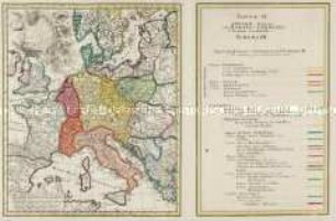
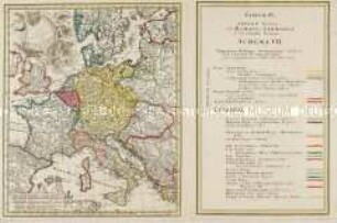
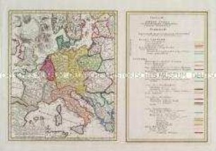
Historisch-Politische Karte
Atlas Historicus: Tabulae IV; Schema V. Imperium Romano-Germanicum sub Friderico III. ad annum eius emortualem 1493
- Alternative title
-
TAB IV. / IMPERII / FRANCICI / vel ROMANO-GERMAN.
- Location
-
Deutsches Historisches Museum, Berlin
- Inventory number
-
Do 2006/1069
- Measurements
-
Höhe x Breite: 56 x 64 cm (Blatt)
Höhe x Breite: 37,7 x 27,7 cm (Karte)
Höhe x Breite: 36,5 x 30,5 cm (Platte 1 (Karte))
Höhe x Breite: 36,5 x 24 cm (Platte 2 (Legende))
- Material/Technique
-
Papier, Kupferstich, koloriert
- Classification
-
Kartografie (Gattung)
- Subject (what)
-
Heiliges Römisches Reich
Deutschland
Mitteleuropa
- Event
-
Herstellung
- (who)
-
Geograph, Kartograf: Johann Matthias Haas
Verlag: Homannsche Erben
- (where)
-
Nürnberg, Deutschland
- (when)
-
1750
- Rights
-
Deutsches Historisches Museum
- Last update
-
24.03.2023, 9:30 AM CET
Data provider
This object is provided by:
Stiftung Deutsches Historisches Museum. If you have any questions about the object, please contact the data provider.
Stiftung Deutsches Historisches Museum. If you have any questions about the object, please contact the data provider.
Object type
- Historisch-Politische Karte
Associated
- Geograph, Kartograf: Johann Matthias Haas
- Verlag: Homannsche Erben
Time of origin
- 1750
Other Objects (12)

Atlas Historicus: Tabulae IV; Schema IV. Imperium Romano-Germanicum sub Friderico II. ad annum eius emortualem 1249
Atlas Historicus: Tabulae IV; Schema III. Imperium Romano-Germanicum sub Conrado II. ad annum ejus emortualem 1031
Atlas Historicus: Tabulae I; Schema VII. Imperium Romano-Germanicum sub Carolo VI. Imp. Invictiss. post compositionem Anni Aer. Chr. 1736
Atlas Historicus: Tabulae IV; Schema II. Imperium Romano Germanicum sub Ottone I. ad annum ejus emortualem 973

Grundriss und Prospect des Welt-berühmten Carlsbad
![Stadtplan und Ansicht von Mannheim, ca. 1:15 000, Kupferst., um 1740 : Hodierna sedes Electoris Palatini Manheimium Ichno- et Scenographice novissime exhibitum / Prostat In Officina Homanniana. - Circa 1:15 000 [Nürnberg] : Officina Homanniana, [um 1740]. - 1 Karte : Kupferdruck, teilweise flächenkoloriert ; Bildgröße 48 x 57 cm, Blattgröße 55 x 64 cm // NO oben. - Windrose unten links. - Titelkartusche rechts Mitte. - Mit einer Ansicht unten unter Kartenbild:Prospect der Churf. Residenz St. Manheim](https://iiif.deutsche-digitale-bibliothek.de/image/2/1331c78a-c92e-456b-9be1-3dcb5bbfc98e/full/!306,450/0/default.jpg)
Stadtplan und Ansicht von Mannheim, ca. 1:15 000, Kupferst., um 1740 : Hodierna sedes Electoris Palatini Manheimium Ichno- et Scenographice novissime exhibitum / Prostat In Officina Homanniana. - Circa 1:15 000 [Nürnberg] : Officina Homanniana, [um 1740]. - 1 Karte : Kupferdruck, teilweise flächenkoloriert ; Bildgröße 48 x 57 cm, Blattgröße 55 x 64 cm // NO oben. - Windrose unten links. - Titelkartusche rechts Mitte. - Mit einer Ansicht unten unter Kartenbild:Prospect der Churf. Residenz St. Manheim
![Karte der Britischen Insel mit den Scilly Islands, 1:1 200 000, Kupferstich, 1793. - Aus: Atlas mapparum geographicarum generalium & specialium Centum Foliis compositum et quotidianis usibus accommodatum - Norimbergae, 1791 : Regni Angliae et Principatus Cambriae Tabula nova : Cum Privil. S. Caes. Maiest. / ad prototypon Kitchinianum edita ab Homannianis Haeredibus. - 1:1 200 000. - [Nürnberg] : Homanniani Haeredes, 1793 . - 1 Kt. : Kupferstich. ; 50 x 57 cm. - Titelkartusche oben rechts. - Mit e. Nebenkt.: Isles of Scilly. - Maßstab in graph. Form (Milliaria Germanica communia, Milliaria Anglica)](https://iiif.deutsche-digitale-bibliothek.de/image/2/a93c58bd-d03d-4cf5-bde0-447a21d9a6bd/full/!306,450/0/default.jpg)
Karte der Britischen Insel mit den Scilly Islands, 1:1 200 000, Kupferstich, 1793. - Aus: Atlas mapparum geographicarum generalium & specialium Centum Foliis compositum et quotidianis usibus accommodatum - Norimbergae, 1791 : Regni Angliae et Principatus Cambriae Tabula nova : Cum Privil. S. Caes. Maiest. / ad prototypon Kitchinianum edita ab Homannianis Haeredibus. - 1:1 200 000. - [Nürnberg] : Homanniani Haeredes, 1793 . - 1 Kt. : Kupferstich. ; 50 x 57 cm. - Titelkartusche oben rechts. - Mit e. Nebenkt.: Isles of Scilly. - Maßstab in graph. Form (Milliaria Germanica communia, Milliaria Anglica)
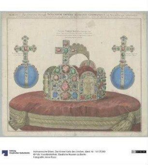
Die Krone Karls des Großen
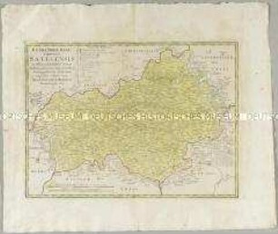
Atlas Regni Bohemiae: Regni Bohemiae Circulus Satecensis
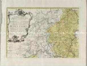
Landgrafiatus Hasso-Cassellanus
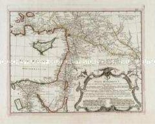
Typus Aetiologicus I.
Militärgeschichtliche Karte - "Plan der R. Vestung Philipsburg nebst der feindlichen Belagerung...vom 23 May bis den 18 July,...1734"
Atlas Historicus: Tabulae IV; Schema IV. Imperium Romano-Germanicum sub Friderico II. ad annum eius emortualem 1249
Atlas Historicus: Tabulae IV; Schema III. Imperium Romano-Germanicum sub Conrado II. ad annum ejus emortualem 1031
Atlas Historicus: Tabulae I; Schema VII. Imperium Romano-Germanicum sub Carolo VI. Imp. Invictiss. post compositionem Anni Aer. Chr. 1736
Atlas Historicus: Tabulae IV; Schema II. Imperium Romano Germanicum sub Ottone I. ad annum ejus emortualem 973
Grundriss und Prospect des Welt-berühmten Carlsbad
Stadtplan und Ansicht von Mannheim, ca. 1:15 000, Kupferst., um 1740 : Hodierna sedes Electoris Palatini Manheimium Ichno- et Scenographice novissime exhibitum / Prostat In Officina Homanniana. - Circa 1:15 000 [Nürnberg] : Officina Homanniana, [um 1740]. - 1 Karte : Kupferdruck, teilweise flächenkoloriert ; Bildgröße 48 x 57 cm, Blattgröße 55 x 64 cm // NO oben. - Windrose unten links. - Titelkartusche rechts Mitte. - Mit einer Ansicht unten unter Kartenbild:Prospect der Churf. Residenz St. Manheim
Karte der Britischen Insel mit den Scilly Islands, 1:1 200 000, Kupferstich, 1793. - Aus: Atlas mapparum geographicarum generalium & specialium Centum Foliis compositum et quotidianis usibus accommodatum - Norimbergae, 1791 : Regni Angliae et Principatus Cambriae Tabula nova : Cum Privil. S. Caes. Maiest. / ad prototypon Kitchinianum edita ab Homannianis Haeredibus. - 1:1 200 000. - [Nürnberg] : Homanniani Haeredes, 1793 . - 1 Kt. : Kupferstich. ; 50 x 57 cm. - Titelkartusche oben rechts. - Mit e. Nebenkt.: Isles of Scilly. - Maßstab in graph. Form (Milliaria Germanica communia, Milliaria Anglica)
Die Krone Karls des Großen
Atlas Regni Bohemiae: Regni Bohemiae Circulus Satecensis
Landgrafiatus Hasso-Cassellanus
Typus Aetiologicus I.